Less Traveled Northwest
Day Hikes for the Adventurous

Upper Sycan River Hike
NOTE: The Upper Sycan River area burned in Bootleg Fire of July 2021. It may be a few years before this area recovers for recreational use.
Hike Rating: Moderate
Hike Length: 4.6 miles roundtrip (from T-Springs)
Elevation Loss: 340’
Trailhead Elevation: 5,450’
Best Season: June through September
Driving Access: Any vehicle
Plus Points
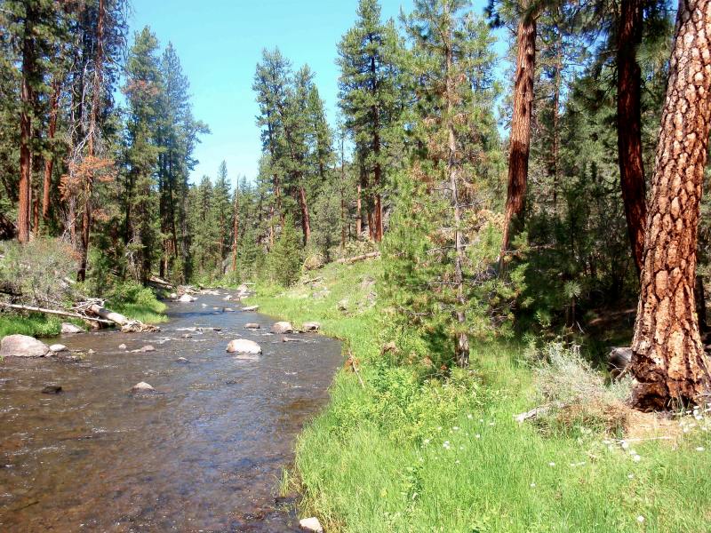
• A designated Wild-and-Scenic river canyon
• Picturesque basalt cliffs and rimrocks throughout the canyon
• Narrow streamside meadows that are ideal for relaxing or exploring
• Old growth ponderosa groves along the river
• Easy, all weather driving access to the trailhead (details below)
• Solitude is almost guaranteed here
Minus Points
• No official trail, so must follow rocky cow trails down into the canyon
• The final 100 yards is a steep scramble over rocks and brush to the river
Download (PDF, 701 KB): Photos of Upper Sycan River Hike
Download (PDF, 360 KB): Topo Map for Upper Sycan River Hike
Download (PDF, 496 KB): Road Map for Upper Sycan River Hike
Trail Notes
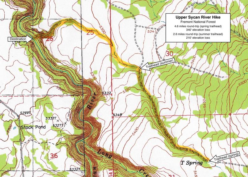
Follow the cow trails down this rocky canyon for about 0.5 miles. As the canyon nears the river, it gets gradually steeper. Finally, the canyon pitches abruptly through a gap in the rimrock to the river below. The best hiking route is on the left (south) side here.

Road to Trailhead
From paved Road 28, drive west on cinder Road 057 for 3.0 miles to the meadow at T-Spring. This road is well-built and can be traveled in nearly any season with a passenger car. Beyond T-Spring, Road 057 becomes a dirt track that may be muddy and impassable in springtime — so plan to park at T-Spring during the wet months.
Later in summer, when this road dries out, one can drive another 1.0 miles on Road 057 to the first road junction and start the hike from there. Downed trees can be encountered on this last mile of road, so having a small chainsaw along can be handy.
Camping Options
The nearest developed campground is the Pikes Crossing Forest Camp, about 8 driving miles southeast of the trailhead, off paved Road 30. It has six free campsites on a grassy bench above Paradise Creek, where it joins the Sycan River. Many beetle-killed lodgepole pines have been cleared around the campground. It has a pit toilet, but no drinking water, and will accommodate any size camping rig.
Agency Contact: Fremont National Forest, Paisley District, (541) 943-3114
DISCLAIMER: Every effort has been made to ensure the accuracy of this information, but the authors do not guarantee that it is either current or correct. The reader assumes full responsibility for any use of this information, and is encouraged to contact local federal land agencies to inquire about current conditions before traveling.
Page last updated: 12/21/11