Less Traveled Northwest
Day Hikes for the Adventurous
Buck Creek Trail
Hike Rating: Easy
Hike Length: 7.2 miles roundtrip (variable)
Elevation Gain: 800’
Trailhead Elevation: 2,430’
Best Season: May through September
Driving Access: Any vehicle
Plus Points
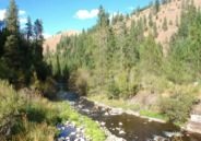
• A hike along a pristine stream canyon, undisturbed by logging, grazing or fire
• Trail is entirely within the North Fork Umatilla Wilderness Area
• Huge cottonwoods along the stream; old-growth douglas fir on streamside terraces
• Lots of bird life in the canyon, including blue grouse and pileated woodpeckers
• Well-built trail, high enough above stream for views of the surrounding hillsides
• Abundant shade trees along trail make for a pleasant hike on a hot day
Minus Points
• Rattlesnakes are a possibility throughout the summer, so caution is advised
• Black bears frequent the trailside berry bushes in Fall, so be alert for them
Download (PDF, 806 KB): Photos of Buck Creek Trail
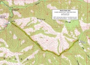
Download (PDF, 833 KB): Topo Map for Buck Creek Trail
Download (PDF, 806 KB): Road Map for Buck Creek Trail
Trail Notes
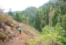
From the Buck Creek Trailhead, the hike follows the north side of the canyon throughout its length, with no stream crossings. For the first half mile, the trail contours above the creek, descending at times onto lush streamside terraces with old-growth douglas firs, ferns, oregon grape and thimbleberry. At 0.5 miles, the trail descends close enough to the creek bed that one can easily wander over to explore along the rushing stream.
For the next two miles, the trail continues up the north side of the stream canyon, staying 50'-100' above the creek, providing nice views into the riparian tree canopy and also onto the hillsides overhead. Notable here are the 150'-tall, straight-trunked cottonwood trees towering at intervals above the creek. At 1.8 miles, the trail rounds a dry, rocky ridge protruding into the canyon and one is aware of the stark contrast between the dry, south-facing hillside and the lush, forested stream corridor below.
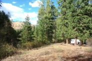
At 2.6 miles, the canyon makes a 90 degree turn to the northeast and the north-facing hillsides become drier, with a mixed douglas fir and ponderosa forest. The trail continues to contour 100' above the stream, though the water can be heard and sometimes seen rushing below. At 3.5 miles, the trail passes the mouth of Lake Creek, joining Buck Creek from the south. About 200 yards past this confluence, there's a pleasant camp on a stream terrace below the trail. It's a short, steep scramble down to this camp, but it makes a wonderful, shady hike and lunch destination under big firs along the creek.
Road to Trailhead
From Hwy 84, about 7 miles east of Pendleton, OR, take Exit 216 for the Wildhorse Casino. Drive about 2.1 miles north to a flashing red light, then turn right (east) onto Mission Road. Follow Mission Road for 1.7 miles, then turn left onto paved Cayuse Road and drive for about 11.2 miles east along the Umatilla River canyon. Between mileposts 15 and 16, just before the hamlet of Thorn Hollow, turn right across the railroad tracks onto paved Bingham Road, following signs for the Bar M Ranch. Drive this road (which becomes Road 32 at the Forest Boundary) for about 16 miles, past the Bar M Ranch Camp, to the Umatilla Forks Campground. The last 3.5 miles to the campground are good graded gravel.
Just past the campground, but before the bridge over the South Fork Umatilla River, look for dirt Road 045 branching to the left (east). Follow Road 045 for 0.2 miles to the trailhead sign at road's end, near the entrance to the Kiwanis Organizational Camp. Park here, taking care not to block the gate into the organizational camp.
Camping Options
The only developed campground in the vicinity is the Umatilla Forks Campground, along Forest Road 32, just 0.2 miles from the trailhead. On a shady bench above the South Fork Umatilla River are 12 sites, 6 of them for tents only and 6 for trailers and tents. There is a vault toilet and a potable drinking water supply. Fees were $10.00 per night in 2013.
For campers with their own water and sanitation, there are 8-10 nice dispersed campsites along the South Fork Umatilla River upstream from the developed campground. These sites are along the river bank, spread out over the three miles between the two river bridges. They are all accessible from the good gravel road running up the canyon, with about half of them suitable for camping trailers and half for tents only.
Agency Contact: Umatilla National Forest, Walla Walla District, (509) 522-6290
DISCLAIMER: Every effort has been made to ensure the accuracy of this information, but the authors do not guarantee that it is either current or correct. The reader assumes full responsibility for any use of this information, and is encouraged to contact local public land agencies to inquire about current conditions before traveling.
Page last updated: 11/26/13


