Less Traveled Northwest
Day Hikes for the Adventurous

McGraw Rim Hike
Hike Rating: Easy
Hike Length: 7.2 miles roundtrip
Elevation Change: 250’
Trailhead Elevation: 5,860’
Best Season: June through September,
once access road is snow-free
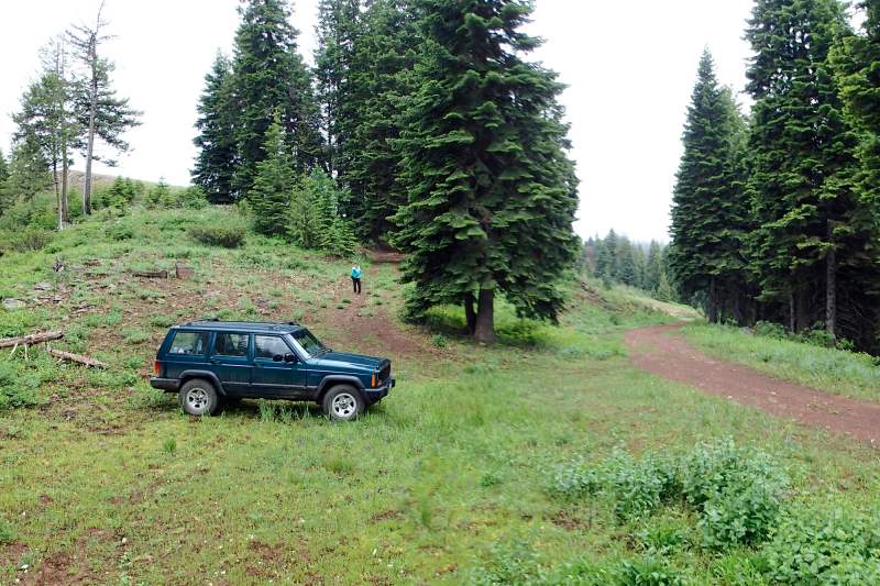
Driving Access: Any vehicle, with extra care
Plus Points
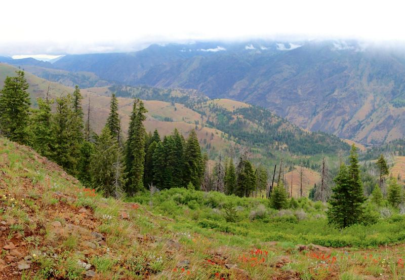
• A cross-country ramble along a remote Hells Canyon rim, with sweeping views
• This rarely used route follows the boundary of Hells Canyon Wilderness Area
• Abundant Spring wildflowers into July, including both dry and moist slope species
• Lots of elk and mule deer sign along the rim, with sightings possible if stealthy
• Hike overlooks the historical 1834 route of the Bonneville Party through Hells Canyon
• The return route is through a beautiful uncut fir forest, on a dirt road behind the rim
Minus Points
• No defined trail, so basic route-finding skills are required to navigate the rim
• Afternoon thunderstorms present a lightning hazard at exposed spots on rim
Download (PDF, 779 KB): Photos of McGraw Rim Hike
Download (PDF, 774 KB): Topo Map for McGraw Rim Hike
Download (GPX, 1 KB): GPS Points for McGraw Rim Hike
Download (PDF, 670 KB): Road Map for McGraw Rim Hike
Trail Notes
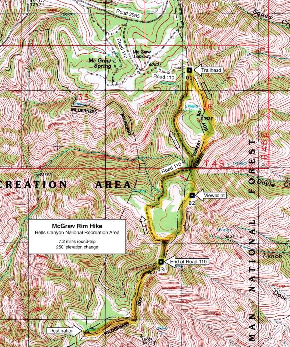
Following the rim south, the route soon descends an open grassy slope, through colorful Spring flowers, to a saddle with thick fir trees at 1.1 miles. One can see Road 110 here to the west. From this saddle, the route follows game trails south up the steep forested hillside to a prominent rock rim at 1.4 miles (GPS Point 2). From this overlook, one has wide vistas east over the benchlands between the rim and river. The 1834 Bonneville Party traversed these same benches in their early explorations of Hells Canyon.

From the end of Road 110, the route follow a prominent trail south along the top of the ridge, through thick brush at first and then over open "balds" with wildflowers (buckwheat, yarrow and desert parsley). For the next mile, it's easy walking on the open bald ridgetop or on game trails at the edge of the trees along the rim. Throughout, one has wide, sweeping vistas east over the Hells Canyon gorge to the southern end of the Seven Devils Mountains on the skyline in Idaho. At 3.6 miles, the rim bends west and ends at basalt rock outcrops — a good hike and lunch destination. Return as you came to the end of Road 110 (GPS Point 3), then follow the road north back to your vehicle. The road passes through beautiful, uncut fir forests, with a thick understory of maple, snowbrush and alder.
Road to Trailhead
Drive up the mountain on gravel road 3962 for about 5.3 miles to a road "T". Turn left (northeast) at this junction onto Road 3965 and drive for 3.2 miles to Road 110 on the right (south). If driving from the north on Road 3965, the turnoff onto Road 110 is about 1.6 miles south from the Buck Creek Campground.
Follow Road 110 (past the McGraw Lookout and intersection with Road 114 at 0.4 miles) for about 0.9 miles to where a dirt road branches off uphill on the left (east). Park in the wide turnout at this road junction and start the hike southeast up the dirt road.
Gravel Roads 3962 and 3965 are accessible by a passenger car or a camping trailer, but with care, as they have lots of potholes. Road 110 is a bit rough and rocky in spots, but a passenger car should be able to make it to the trailhead, if one is quite careful.
Camping Options

Agency Contact: Hells Canyon National Recreation Area, (541) 426-5546
DISCLAIMER: Every effort has been made to ensure the accuracy of this information, but the authors do not guarantee that it is either current or correct. The reader assumes full responsibility for any use of this information, and is encouraged to contact local public land agencies to inquire about current conditions before traveling.
Page last updated: 12/10/14