Less Traveled Northwest
Day Hikes for the Adventurous
Home Creek Hike
NOTE: All visitors to Home Creek Canyon must first obtain written permission from Roaring Springs Ranch. Please call (541) 495-2263, during normal business hours.
Hike Rating: Difficult
Hike Length: 2.5 miles roundtrip (variable)
Elevation Gain: 350’
Trailhead Elevation: 4,600’
Best Season: June through September
Driving Access: Any vehicle
Plus Points
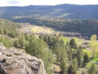
• A short, but very challenging, cross-country hike into a dramatic and scenic canyon
• Within the Catlow Rim portion of the Steens Mountain Wilderness Area
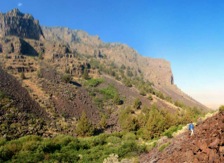
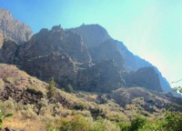
• Basalt palisades and cliffs rise over 1,000’ above a small perennial stream
• Songbirds are common in the streamside willow and cottonwood thickets
• Potential bighorn sheep sightings on the high rock rims and ledges
• Solitude is almost assured in this seldom-visited canyon
Minus Points
• Extremely rugged hike over steep, loose talus slopes and boulder fields
• Rattlesnakes are a possibility throughout the summer, so caution is advised
• Hike can be hot in midsummer, so plan to start in the early AM and return by noon
Download (PDF, 427 KB): Photos of Home Creek Hike
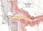
Download (PDF, 545 KB): Topo Map for Home Creek Hike
Download (PDF, 591 KB): Road Map for Home Creek Hike
Trail Notes
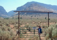
After first obtaining permission from Roaring Springs Ranch (see notice above), the hike starts at a green steel gate with a “No Trespassing” sign on the east side of Hwy 202. Once through the gate, follow the jeep road east for about 0.3 miles to an old homestead site and a “Wilderness Boundary” marker. Look for sage grouse in this area. The route then follows an old irrigation ditch that contours along the north side of Home Creek for several hundred yards until it ends at the creek. From here, one needs to strike out cross-country through the rocks and juniper trees, staying above the dense thickets along the creek but below the talus sloper higher up.
At about the 0.7 mile point, one has no choice but to hike over the broad talus slopes and boulder fields covering the north side of the canyon. Though the south side of the canyon may look better at times, there’s really no benefit from crossing over.
As one ascends further up the canyon, the boulder fields become steeper, more unstable and more hazardous. Go only as far as your hiking skills and comfort level allow. At several points along the creek there are small open areas with shady juniper trees, which make a good lunch and hike destination. One doesn’t need to go very far up the canyon to experience the dramatic basalt palisades, spires and sentry peaks eroded out of the 1,000’-high cliffs. With binoculars, one can glass for bighorn sheep on the high rock rims and ledges.
Road to Trailhead
From the small hamlet of Frenchglen, turn west on paved Hwy 205 (which soon turns into Hwy 202), and drive about 23 miles south. The hike starts at a green steel gate with a “No Trespassing” sign on the east side of the highway, about 150 yards north of where Home Creek crosses in a culvert under the highway. Park on either shoulder of the highway, well off the roadway, taking care not to block the entrance to the gate.
NOTE: Prior written permission from Roaring Springs Ranch is required. Please call (541) 495-2263 during normal business hours. Continued access to this day hike is only by the good graces of the Ranch, so please respect the privilege — no overnight camping, no fires, no firearms, no dogs and no littering.
Camping Options
The nearest developed campground is the BLM Page Springs Campground. It is located about 3 miles east of Frenchglen on the Steens Mountain Loop Road and is about 26 driving miles from the trailhead. It’s been developed around several large springs below a basalt rim along the Donner und Blitzen River and is a pleasant spot, though mosquitoes can be thick here in summer. It has 36 sites, each with a gravel parking pad, concrete picnic table and fire ring. There are vault toilets, drinking water, trash cans and a camp host in summer. The fee was $8.00 a night in 2012.
The next nearest campground is the South Steens Campground, also managed by the BLM. It’s located 18 miles east of Hwy 205 on the southern leg of the Steens Mountain Loop Road and about 32 driving miles from the trailhead. This campground is split into two parts, with 21 standard sites for family campers and 15 sites for equestrians. The campsites are all dispersed through a juniper-covered grassland, some with shade and some more exposed. All have gravel parking pads, picnic tables and fire rings. Both campgrounds provide vault toilets, drinking water and trash cans. Fees were $6.00 per night in 2012.
Agency Contact: Burns BLM District, (541) 573-4411
DISCLAIMER: Every effort has been made to ensure the accuracy of this information, but the authors do not guarantee that it is either current or correct. The reader assumes full responsibility for any use of this information, and is encouraged to contact local federal land agencies to inquire about current conditions before traveling.
Page last updated: 10/28/15

