Less Traveled Northwest
Day Hikes for the Adventurous

Bamber Ridge Hike
Hike Rating: Moderate
Hike Length: 7.8 miles roundtrip
Elevation Gain: 1,480’
Trailhead Elevation: 3,300’
Best Season: May to September
Driving Access: Any vehicle, with care
Plus Points
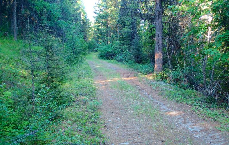
• A hike up abandoned logging roads leading to a cross country, ridge top ramble
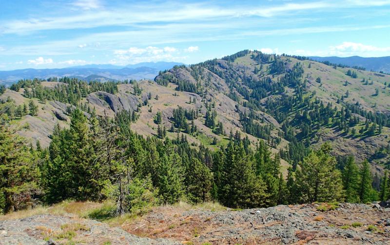
• Part of the Bodie Mtn. Roadless Area, the ridge crest has superb panoramic vistas
• Old-growth fir and larch forests are found along Bamber Creek on the approach hike
• The old logging roads are closed to motorized vehicles and have good hiking grades
• The ridge crest features open grassy slopes, rock outcrops and spring wildflowers
• Complete solitude is nearly guaranteed on this seldom-traveled ridge hike
Minus Points
• Afternoon thunderstorms may present a lightning hazard on the exposed ridge crest
• A few cows may be encountered along the ridge later in the hiking season
• Rattlesnakes are a possibility on the open, rocky ridge — so be aware
Download (PDF, 828 KB): Photos of Bamber Ridge Hike
Download (PDF, 841 KB): Topo Map for Bamber Ridge Hike
Download (GPX, 2 KB): GPS Points for Bamber Ridge Hike
Download (PDF, 633 KB): Road Map for Bamber Ridge Hike
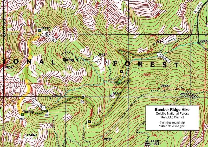
From the tiny trailhead parking area, the trail first climbs over three big barrier mounds in the road and then starts a long gradual ascent along abandoned logging roads toward the ridge top. At 0.5 miles, the road crosses a dry stream bed, and just beyond one can spot scattered western red cedars in the ravine below the road.
At 0.8 miles and another barrier mound (GPS Point 1), the road forks and one takes the left-hand (southerly) road. Within 200 yards, this road crosses Bamber Creek on a wide switchback, amid primeval riparian forests that were never logged. Past the creek, the road continues its long gradual ascent, first to the east then back southwest, as it climbs the hillside on an easy grade. Most of the forest here is second-growth fir and larch, but the road itself is lined with shady, overhanging maple and alder.
Past the spring, the route continues up the old road bed on the south side of the creek on an overgrown cow trail for about 300 yards, to where the trail crosses the spring canyon and begins contouring north. At the first open grassy slope north of the creek, the route leaves the trail and climbs cross-country for about 300 yards through open forest, arriving on the ridge crest in a grassy saddle with stands of douglas fir at 2.9 miles (GPS Point 5). Here one has the first panoramic vistas west over the Toroda Creek canyon and beyond to Bonaparte Mountain on the far horizon.
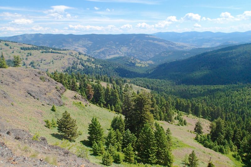
At 3.7 miles, following a fence line along the ridge into a forested saddle, one sees a vertical rock wall ahead. The route contours to the right (east) of this rock cliff and climbs up the grassy/rocky slope to the summit of Point 4772 at 3.9 miles (GPS Point 6), the hike's destination. This is the premier viewpoint along the ridge, with vistas north to Bamber Mountain, west over Toroda Creek to the snowy Cascades, and east to the Kettle River Range. If feeling ambitious, one can hike north along the ridge for another mile, all the way to the 4,986' summit of Bamber Mountain. Return as you came.
Road to Trailhead
On the West Kettle River Road (Hwy 50), about 9 miles northwest of the town of Curlew and 1 mile southeast of the Toroda Junction, turn west on paved Bamber Creek Road (at the Curlew Job Corps sign). Drive uphill about 0.6 miles to the Job Corps Center entrance, then turn uphill onto the major gravel road leading to the southwest.

Past the Forest boundary, drive downhill for 0.25 miles to Road 500, the first dirt road on the right (west), with a "Road Closed in 1/2 Mile" sign. Follow Road 500 west, past a cattle guard, to where it is blocked off. This trailhead has a turnaround and tiny parking area, big enough for two cars. Any passenger car should be able to negotiate Road 500, with care.
Camping Options
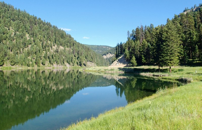
The nearest developed campgrounds are the USFS Beaver Lake and Beth Lake Campgrounds, about 20 driving miles west of the trailhead on the paved Chesaw Road. Beaver Lake CG has 9 campsites for tents or small travel trailers on a
For those campers completely self contained with their own drinking water and sanitation, there is one small dispersed camping site (for tents only) on the south bank of Bamber Creek at the Road 800 crossing, just 0.8 driving miles from the trailhead. Further south on Road 800, at its junction with Road 850 and about 0.7 miles from the Bamber Creek crossing, there several more dispersed sites suitable for tents or a small camping trailer.
Agency Contact: Colville National Forest, Republic District, (509) 775-7400
DISCLAIMER: Every effort has been made to ensure the accuracy of this information, but the authors do not guarantee that it is either current or correct. The reader assumes full responsibility for any use of this information, and is encouraged to contact local public land agencies to inquire about current conditions before traveling.
Page last updated: 11/1/15