Less Traveled Northwest
Day Hikes for the Adventurous

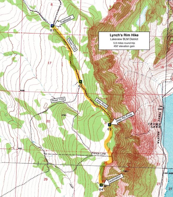
Lynch’s Rim Hike

Hike Rating: Easy
Hike Length: 5.9 miles roundtrip (variable)
Elevation Gain: 450’
Trailhead Elevation: 6,480’
Best Season: June through September
Driving Access: High-clearance vehicle,
once access road is snow-free and dry
Plus Points
• Easy walking access to a high, scenic rim within a BLM Wilderness Study Area
• Spectacular, panoramic overviews of Warner Valley lakes and Hart Mountain plateau
• Pronghorn antelope and mule deer are common on the sage-juniper uplands
• Aeries (stick nests) of bald eagles, golden eagles and prairie falcons on rimrock ledges
• Possible bighorn sheep sightings on uplands and ledges below the rim
• Some of the best mountain mahogany stands in Southeast Oregon
Minus Points
• Afternoon thunderstorms can present a lightning hazard on the exposed rims
• Access road requires high-clearance vehicle and is slippery when wet (details below)
Download (PDF, 564 KB): Photos of Lynch’s Rim Hike
Download (PDF, 660 KB): Topo Map for Lynch’s Rim Hike
Download (GPX, 4 KB): GPS Points for Lynch’s Rim Hike
Download (PDF, 671 KB): Road Map for Lynch’s Rim Hike
Trail Notes
To continue south along the rim, it’s best to walk along the low sage just behind the mountain mahogany thickets on the rim’s edge, rather than fight the brush right along the rim. After just a half mile south, one encounters an east-west fence line, which can be followed east to the rim’s edge and a second spectacular rim viewpoint.

Road to Trailhead
From the town of Plush, drive 6.2 miles west on the paved Plush Cutoff Road. Look for a major dirt road to the south, with a BLM “Road 7105” marker. Follow Road 7105 about 7.6 miles south to a signed junction with the Cleland Springs Road (GPS Point 1). There’s plenty of off-road parking at this junction, so avoid blocking either road.

Camping Options
The nearest developed campground is at Camp Hart Mountain, an old CCC camp located in the Warner Valley about 28 miles from the trailhead and about 15 miles north of Plush on the road to the Hart Mountain Antelope Refuge. This campground has 9 free campsites that will accommodate any size camping rig, vault toilets and drinking water. It has a camp host during the summer and is managed by the U.S. Fish and Wildlife Service.
If tent camping, with your own sanitation and water, there are some nice dispersed campsites along Road 7105, about 3 miles in from the Plush Cutoff Road junction and 4.6 miles below the trailhead. These sites are just west off Road 7105 in aspen groves under a low rimrock, about a half-mile before one gets to Bull Lake (dry).
Agency Contact: Lakeview BLM District, (541) 947-6399
DISCLAIMER: Every effort has been made to ensure the accuracy of this information, but the authors do not guarantee that it is either current or correct. The reader assumes full responsibility for any use of this information, and is encouraged to contact local federal land agencies to inquire about current conditions before traveling.
Page last updated: 1/16/13