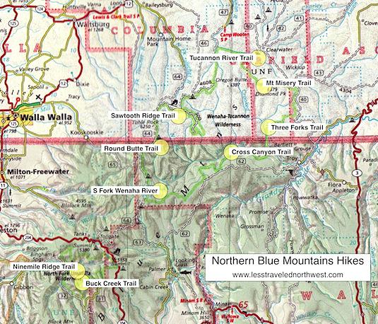
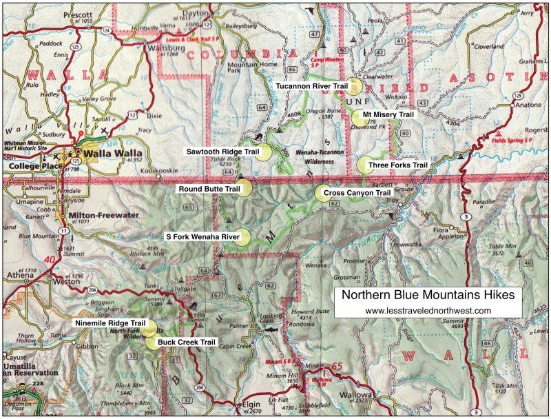
Northern Blue Mountains Hikes
The Northern
Blues are "upside-down mountains." Instead of the towering,
ice-sculpted granite peaks of the Southern Blues, one finds
deep, steep-walled canyons eroded into flat, elevated
basalt plateaus. The tops of these plateaus have most of
the forest roads, the logging activity and the grazing. But
the rugged, incised canyons and narrow rocky ridges between
them are roadless and pristine, forming the vast
Wenaha-Tucannon Wilderness and the smaller North Fork
Umatilla Wilderness — the two best hiking destinations in
the Northern Blue Mountains.
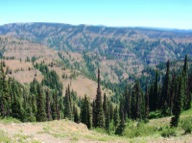
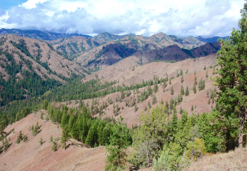
The most
striking geologic feature of the Northern Blues is their
basalts — countless horizontal bands laid down 5 to 15
million years ago in a volcanic layer cake, thousands of
feet thick. Subsequent erosion exposed these layers on the
sides of deep, steep-walled canyons. Also notable is the
contrasting vegetation — sparse bunchgrass on the dry,
south-facing slopes and thick fir and larch forests on the
moister, north-facing slopes. The vegetation is also
stratified by soil chemistry, where some exposed strata
support healthy trees and shrubs and others are "balds,"
with only thin grasses. This mosaic of grassland and forest
is excellent elk habitat and supports one of the densest
concentrations of Rocky Mountain elk in the U.S.
Download
(PDF, 334 KB): Location Map of Northern Blue Mountains
Hikes
Download
(PDF, 792 KB): Photos of the Northern Blue
Mountains
Fortunately for day hikers, the forest roads in the
Northern Blues closely surround and even penetrate into the
wilderness areas, creating good access for day trips into
remote spots. The easiest day hikes either follow narrow
ridgelines into the wilderness, with wide views of the
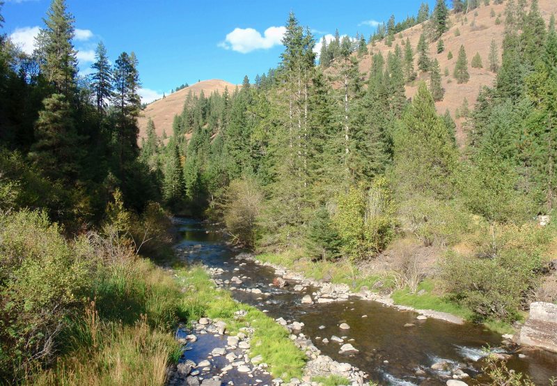
surrounding canyons, or they follow river courses through
lush riparian forests on the canyon bottoms. More
challenging and dramatic day hikes begin on the plateau
rims and switchback down over 1,500' into the picturesque
canyons. Developed campgrounds are found around the
wilderness edges, though a few spots require dispersed
camping with one's own water and sanitation. Gas and
supplies are available in the surrounding towns, including
Tollgate OR, Troy OR, Athena OR, Dayton WA, Pomeroy WA, and
Asotin WA.
Hiking activity in the Northern Blue Mountains is less
concentrated than in the Southern Blues, due to the better
road access. However, popular and overused day hikes do
exist, including the Oregon Butte hike in the
Wenaha-Tucannon Wilderness (the highest peak in the
wilderness) and the North Fork Umatilla River hike (the
largest river in this wilderness). Those day hikers not
compelled by the "highest and largest" will find many
enticing alternative hikes, where solitude and a pure
wilderness experience beckon.
Westside
Wenaha-Tucannon Wilderness Hikes
With
elevations up to 6,000', this is the higher side of the
wilderness, with the most access roads and developed
campgrounds. A few of the easier day hikes are found here
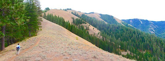
as well. The 3.8-mile (one way) Sawtooth Ridge Trail starts
at an easily-accessible trailhead, then follows a broad
ridgeline south into the heart of the wilderness, with
sweeping views over the North Fork Wenaha watershed. The
3.6-mile ridgeline trail to Round Butte can only be reached
by a high-clearance vehicle, but is arguably the most
scenic ridge hike in the wilderness and is prime summer
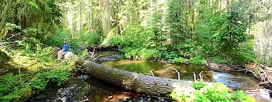
habitat for elk. The easily-accessible Tucannon River Trail
follows the north side of the river for 4 miles through
primeval fir forests to its confluence with Bear Creek.
> Sawtooth Ridge
Trail
> Round Butte
Trail
> Tucannon River
Trail
Eastside
Wenaha-Tucannon Wilderness Hikes
With
trailhead elevations around 4,000', this is the lower and
more remote side of the wilderness, with fewer developed
campgrounds — so dispersed camping is required in a few
areas. But it offers a few of the most dramatic and
challenging day hikes in the wilderness. The gentle
3.2-mile trail into the South Fork Wenaha basin is perhaps
the finest forest hike here, through groves of pristine
grand fir. The strenuous Cross Canyon Trail switchbacks
down 1,750' in 2.8 miles into the scenic Wenaha River
canyon, with the potential for Shiras moose sightings at
the bottom. The equally demanding Three Forks Trail
descends 1,600' in 3.2 miles into the picturesque Crooked
Creek canyon. Finally, the higher-elevation Mt. Misery
Trail traverses a 6,000'-high rim for 4 miles, with
panoramic wilderness vistas throughout, plus a side visit
to scenic Diamond Peak.
> South Fork Wenaha River
Trail
> Cross Canyon
Trail
> Three Forks
Trail
> Mount Misery
Trail
North
Fork Umatilla Wilderness Hikes
At just over
30 square miles, this smaller of the two wilderness areas
is also the lowest, with elevations from 2,200' to 4,600'.
But it's nearly identical to its larger sibling, with
layers of basalt incised by deep stream canyons and dry,
grassy hillsides next to moister, forested slopes. A good
access road leads to a campground and several nice
dispersed campsites at riverside along the wilderness
boundary. The best view hike is the Ninemile Ridge Trail,
which gradually switchbacks up over 1,200' in 2.3 miles to
sweeping wilderness vistas, then ascends the spine of the
ridge to even higher viewpoints. A pleasant, less-traveled
creek hike follows the Buck Creek Trail for 3.6 miles
through pristine riparian forests of tall cottonwood and
fir to a shady streamside camp.
> Ninemile Ridge
Trail
> Buck Creek
Trail
Clickable
map of Northern Blue Mountains
hikes:
Page last updated:
11/17/13


