McCoy Creek Hike
Hike Rating: Moderate
Hike
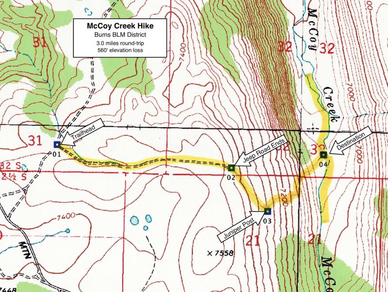
Length: 3.0 miles roundtrip (minimum)
Elevation Loss: 560’
Trailhead Elevation: 7,420’
Best Season: June and September, before and
after
cows are in the valley
Driving Access: Any vehicle, once access
road
is snow-free and dry
Plus
Points
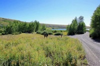
• A rugged, cross-country hike into a once-glaciated valley
with a perennial stream
• This section of McCoy Creek is within a BLM Wilderness
Study Area
• Very scenic hike at points, with expansive vistas up and
down the U-shaped valley
• Valley bottom is a mosaic of open meadows, streamside
willows and aspen groves
• Potential sightings of antelope in sage uplands and mule
deer in valley bottoms
• Solitude is nearly assured in this seldom-visited valley
Minus Points
• Grazing cows dominate the
valley from July to mid-August — a good time to avoid
• A short, steep scramble down into the valley, dropping
500’ in one-third mile
• Basic orienteering or GPS skills are needed to follow the
best route into valley
Download (PDF, 535 KB): Photos of McCoy Creek
Hike
Download
(PDF, 580 KB): Topo Map for McCoy Creek
Hike
Download
(GPX, 4 KB): GPS Points for McCoy Creek
Hike
Download
(PDF, 656 KB): Road Map for McCoy Creek
Hike
Trail
Notes
The hike
begins on a faint, double-track jeep trail that runs up a
grassy swale to the east of the trailhead (GPS Point 1).
For the next 0.7 miles, the route follows this jeep track
east through the sage scrub, bearing toward the Kiger Notch
on the horizon, until it ends just over the lip of the
valley’s edge (GPS Point 2). From here, the route strikes
off cross-country to the southeast, slowly descending the
sage-covered hillside for about 0.2 miles, to a prominent
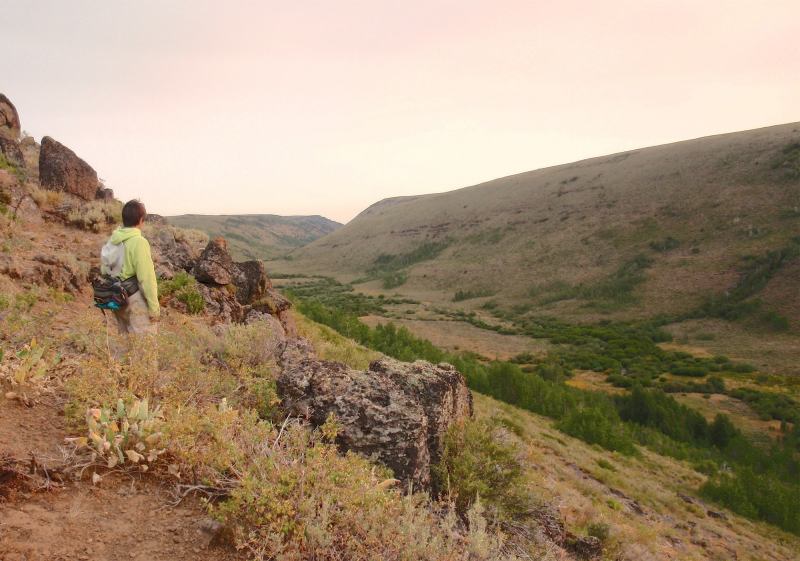
juniper post on a rocky rim (GPS Point 3). Here, there are
wonderful, sweeping views up and down the U-shaped valley
of McCoy Creek. For the next 0.4 miles, from this juniper
post to McCoy Creek, the route descends northeast down the
steep, rocky hillside into the McCoy Creek valley at GPS
Point 4.

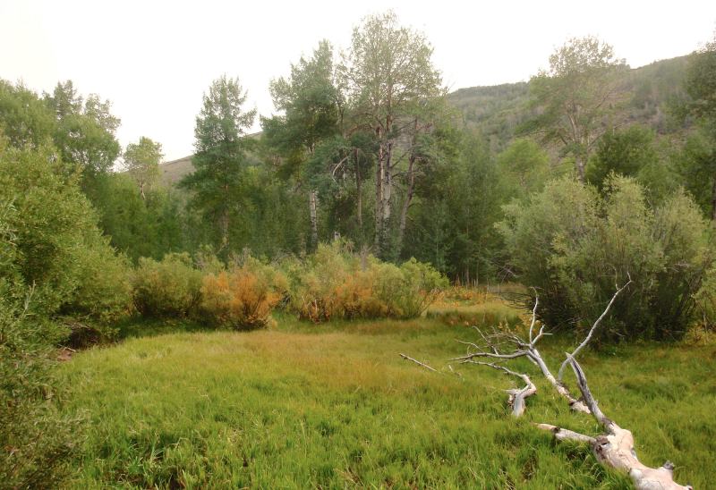
Once at the
valley floor, there’s ample opportunity to explore both
upstream and downstream. The lower end of McCoy Creek is a
diverse mosaic of open grassland, streamside willow
thickets and isolated aspen groves — and it’s easy walking
for about 0.9 miles downstream until one meets fenced
private land. Heading upstream, there’s a good cow trail up
the east side of the valley, if the creek level is low
enough to cross safely. For over a half mile, this trail
winds through thick, nearly continuous stands of aspen,
interspersed with a few attractive wet meadows sporting
wildflowers late into the season. Return along the same
route as you came.
Road to Trailhead
The access
road to the trailhead is an easy one that, if dry, is
passable by any passenger car. On the Steens Mtn. Loop
Road, drive about 0.4 miles west from the Fish Lake
Campground or about 13.2 miles east from the Page Springs
Campground. Turn northeast on a good dirt road and drive
about 0.4 miles to where the road dips through a shallow,
grassy swale. On the right (east) side of the road, there
should be a “Wilderness Boundary” marker and a faint jeep
track heading east up the swale.
Camping Options
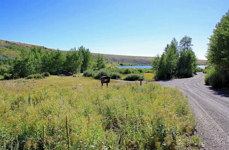
For all
campers: The nearest developed campground is the Fish Lake
Campground, managed by the BLM. It’s located at 7,400’ on
the Steens Mtn. Loop Road, about 17 miles west of
Frenchglen and about 1 driving mile from the trailhead.
This campground has 23 sites around a small mountain lake,
some tucked away in aspen groves at the head of the lake
and others more exposed near the lake’s outlet. All have
gravel parking pads, tables and fire rings. There are vault
toilets here, drinking water, trash cans and a small boat
ramp (for motor-less boats only). The fee was $8.00 per
night in 2012.
For tent campers only: The next nearest campground is the
Jackman Park Campground, managed by the BLM. It’s located
at 7,800’ on the Steens Mtn. Loop Road, 19 miles east of
Frenchglen and about 3 driving miles from the trailhead.
This campground is nestled within a small basin of aspen
groves and wet meadows below a glaciated rim. There are 6
small sites for tents, though one of the sites can
accommodate a small tent or travel trailer. Each site has a
concrete picnic table and fire ring. The campground has a
vault toilet, drinking water and trash cans. The fee was
$6.00 per night in 2012.
Agency
Contact: Burns BLM District, (541)
573-4411
DISCLAIMER:
Every effort has been made to ensure the accuracy of this
information, but the authors do not guarantee that it is
either current or correct. The reader assumes full
responsibility for any use of this information, and is
encouraged to contact local federal land agencies to
inquire about current conditions before
traveling.
Page
last updated: 1/17/13