Less Traveled Northwest
Day Hikes for the Adventurous

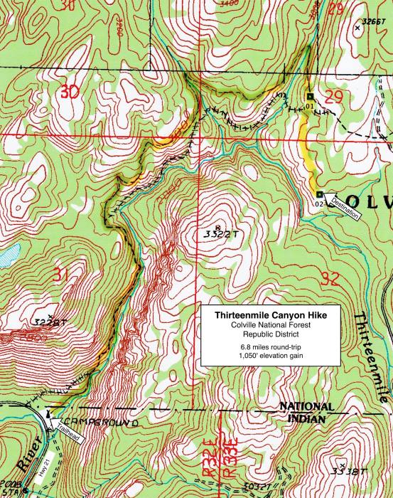
Thirteenmile Canyon Hike
Hike Rating: Moderate
Hike Length: 6.8 miles roundtrip
Elevation Gain: 1,050’
Trailhead Elevation: 2,050’
Best Season: April-June and September
Driving Access: Any vehicle
Plus Points
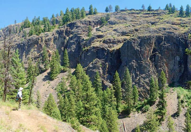
• A canyon hike within and above a glaciated gorge, with scenic 600' granite cliffs
• Trail is within the Thirteenmile Roadless Area and is closed to motorized travel
• Birdlife is abundant throughout the canyon, especially in the tall cottonwood groves
• A diverse mix of both dry and wet slope spring wildflowers, blooming into mid-July
• Trail is well-built on a good grade, with switchbacks and water bars where needed
• One of the earliest hikes in the Okanogan Highlands to become snow-free in spring
Minus Points
• Solitude is not guaranteed, as the trail is easily accessible from State Hwy 21
• Long stretches of trail are without shade, so get an early AM start on hot days
• Rattlesnakes are common throughout the canyon in summer, so be aware
Download (PDF, 697 KB): Photos of Thirteenmile Canyon Hike
Download (PDF, 686 KB): Topo Map for Thirteenmile Canyon Hike
Download (GPX, 1 KB): GPS Points for Thirteenmile Canyon Hike
Download (PDF, 642 KB): Road Map for Thirteenmile Canyon Hike
From the trailhead bulletin board on the north end of the campground, the trail first climbs gradually up the west side of Thirteenmile Creek through thick stands of douglas fir, then traverses a few rocky talus slopes, all within sight and sound of the burbling stream. At 0.5 miles, the trail starts a series of long switchbacks up the west side of the canyon, topping out on a long flat bench with spectacular views of the 600'-high, glaciated granite walls just across the canyon to the east.
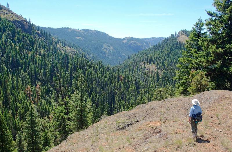
On this bench high above the stream, the trail follows the rock ledge north for about 0.6 miles, through a mixed forest of douglas fir, western larch and ponderosa pine. At about 1.2 miles, the trail loops west into the first of the sylvan glades found on tributary streams draining east into the canyon, thick with currants, wild roses and shrub maples and stands of old-growth trees that have never been logged.
Past this first small tributary canyon, the trail alternates between traverses of open, rocky bluffs and retreats back into the green shady tributary canyons (all normally dry by July). From the high bluff overlooks, one has long vistas south down Thirteenmile Creek to the Sanpoil River canyon and also east to the rounded ridges of the stream's headwaters. Though the long views are wonderful, the shady tributary canyons are equally appreciated on hot days, along with their abundant birdlife.
Road to Trailhead
From the junction of Highways 20 and 21, just south of Republic, WA, drive south on Hwy 21 for 12.3 miles, through the Sanpoil River Valley, to the signed Thirteenmile Trailhead on the left (east), at the boundary of the Colville Indian Reservation. The trail starts just west of the double vault toilet at the head of the campground, near a bulletin board. This trailhead is easily accessible by any passenger car or camping vehicle.
Camping Options

NOTE: The USFS Ten Mile Campground, just 3 miles north of the trailhead on Hwy 21, has been closed due to storm damage for the past few years, and appeared abandoned in June 2015. Contact the USFS district office in Republic for an update. This was once a nice campground on the Sanpoil River, with 9 sites suitable for both tents and camping trailers, each with a picnic table and fire ring, plus a vault toilet, but no drinking water.
Further afield, there are three USFS campgrounds at Swan, Ferry and Long Lakes, about 12 driving miles west of the trailhead on paved Road 53 (aka Scatter Creek Road), off Hwy 21. These are developed campgrounds with vault toilets, drinking water and are suitable for any type of camping setup. Camping fees were $6-$10 per night in 2015.
Agency Contact: Colville National Forest, Republic District, (509) 775-7400
DISCLAIMER: Every effort has been made to ensure the accuracy of this information, but the authors do not guarantee that it is either current or correct. The reader assumes full responsibility for any use of this information, and is encouraged to contact local public land agencies to inquire about current conditions before traveling.
Page last updated: 11/1/15