Less Traveled Northwest
Day Hikes for the Adventurous

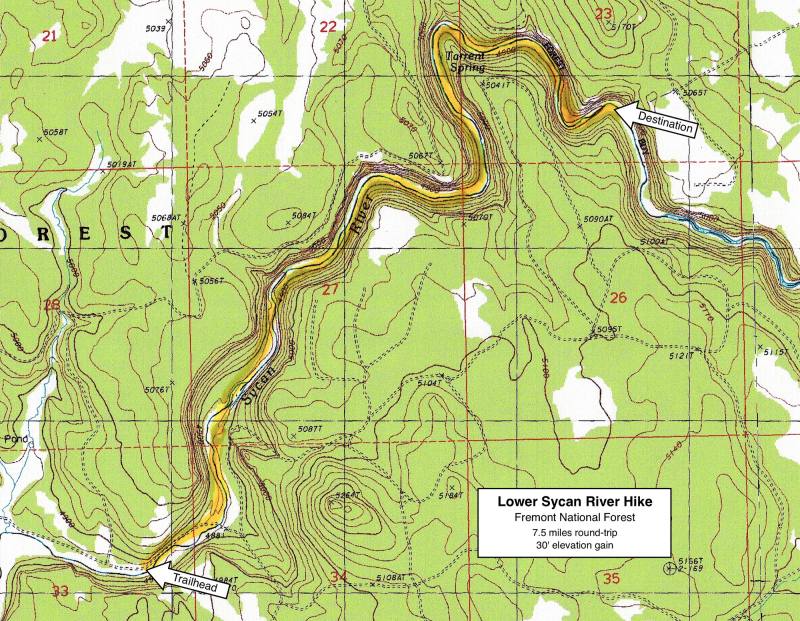
Lower Sycan River Hike
NOTE: The Lower Sycan River area burned in Bootleg Fire of July 2021. It may be a few years before this area recovers for recreational use.
Hike Rating: Moderate
Hike Length: 7.5 miles roundtrip (variable)
Elevation Gain: 30’
Trailhead Elevation: 4,870’
Best Season: July through September;
after spring runoff has subsided
Driving Access: Any vehicle, when dry
Plus Points
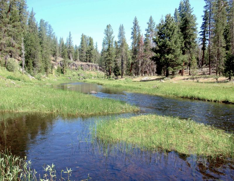
• A designated Wild-and-Scenic river canyon, with basalt rimrocks
• Cool, pleasant walk along (and through) a flowing stream
• Scattered, old growth ponderosa pines throughout the canyon
• Verdant meadows at streamside below dry, upland pine forests
• Numerous springs and seeps support wildflowers into late summer
• Solitude is nearly guaranteed here
Minus Points
• No developed trail, but cow trails are easy to follow along the steam banks
• 6-8 knee-deep stream crossings, so wear appropriate footwear
• Mosquitoes can be present, so be sure to have repellent along
Download (PDF, 593 KB): Photos of Lower Sycan River Hike
Download (PDF, 392 KB): Topo Map for Lower Sycan River Hike
Download (PDF, 456 KB): Road Map for Lower Sycan River Hike
Trail Notes
The streamside meadows are flanked by lodgepole and ponderosa pine, with an understory of spirea and gooseberry. Wildflowers persist well into late summer here, due to the many springs and seeps along the canyon walls. On the rock benches high above the stream stand stately, old growth ponderosas.

Road to Trailhead
Access to the trailhead is over good roads, once they have dried out in the spring. From gravel Road 46, turn southeast onto Road 4650 and follow it for about 4.2 miles, where it meets the Sycan River. From here, continue upstream on this road for about 0.5 miles, along the north bank of the river, until the road ends at a crude parking lot. A rough jeep trail does continue upstream for another quarter mile to the Sycan River Ford, but this section is much better walked than driven!
Camping Options
If you are self-sufficient (with your own water and sanitation) and your camping setup is not overly big (anything less than the largest travel trailers), then there are 4 or 5 very nice dispersed camping spots on the north bank of the Sycan River, spread out for about a half-mile below the trailhead.
The closest developed campground is the Head-of-the-River Campground in the Winema National Forest, about 10 road miles from the trailhead, off gravel Road 46. Here are six free developed campsites, with a vault toilet, but no drinking water. The campground is tucked away in a pine forest next to the big spring that begins the Williamson River. It will accommodate any size camping setup.
Agency Contact: Fremont National Forest, Chiloquin District, (541) 783-4001
DISCLAIMER: Every effort has been made to ensure the accuracy of this information, but the authors do not guarantee that it is either current or correct. The reader assumes full responsibility for any use of this information, and is encouraged to contact local federal land agencies to inquire about current conditions before traveling.
Page last updated: 12/21/11