Less Traveled Northwest
Day Hikes for the Adventurous

Crab Creek Coulee Hike
Hike Rating: Moderate
Hike Length: 6.8 miles roundtrip
Elevation Gain: 190’
Trailhead Elevation: 1,670’
Best Season: April-May and September
Driving Access: Any vehicle
Plus Points
• A scenic, cross-country walk along a coulee rim, for lovers of desert solitude
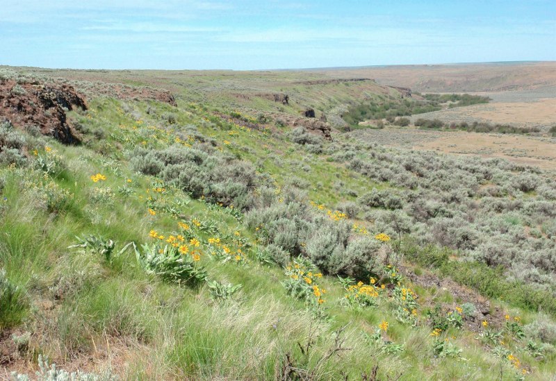
• Overviews of the Crab Creek coulee, with basalt bluffs sculpted by Ice Age floods
• Mima mound topography on the flat benchlands above the coulee rim
• Showy balsamroot and white lupine on the moist, north-facing slopes in Spring
• A cool, shady hike destination awaits at the banks of perennial Crab Creek
• Solitude is nearly unavoidable on this hike
Minus Points
• No shade or tree cover, so it's best to start in the early AM on hot days
• Route is mostly cross-country over uneven ground, so sturdy footwear is a must
• Rattlesnakes are a possibility throughout the summer, so be aware
Download (PDF, 673 KB): Photos of Crab Creek Coulee Hike
Download (PDF, 709 KB): Topo Map for Crab Creek Coulee Hike
Download (PDF, 667 KB): Road Map for Crab Creek Coulee Hike
Trail Notes
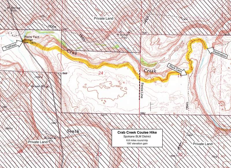
Cow trails appear and disappear along the rim's edge, but route finding is easy as long as one contours along the same rock layer. At about 1.8 miles, the route crosses a north-south fence line and wide, sweeping views open up over Crab Creek and the coulee to the east. Past this fence, it may be tempting to drop down to lower benches along the rim, but the easiest route is to just maintain the same contour level. In Spring, look for colorful arrowleaf balsamroot and white lupine on the north-facing slopes below the rim.

Road to Trailhead
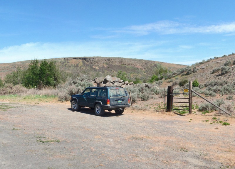
From State Route 28, about 15 miles east of Odessa and 9.5 miles west of Harrington, turn south on paved Doggett Road. Drive south 1.6 miles, curving southeast and crossing the railroad tracks, to a "T". Turn left here (east on Tanke Road) and drive 0.5 miles to the top of the hill, then turn right (south) onto gravel Rocky Ford Road. Drive 5 miles south on Rock Ford Road to the concrete bridge over Crab Creek. Park at the pullout southeast of the bridge. The trailhead is the green steel pedestrian gate in the fence.
Camping Options
The nearest public camping area is the BLM Pacific Lake/Lakeview Ranch Campground, about 30 driving miles from the trailhead, north of Odessa on the Lakeview Ranch Loop Road. Here, near the old Lakeview Ranch buildings and corrals, on a flat bench above now dry Pacific Lake, are a vault toilet and gravel parking areas suitable for travel trailers.

Camping is also available at two private resorts on Sprague Lake, east of the trailhead near the town of Sprague off Interstate 90. These campgrounds offer full hookups, showers and rest rooms, but they're relatively expensive and near the freeway and railroad tracks.
Agency Contact: Spokane BLM District, (509) 536-1200
DISCLAIMER: Every effort has been made to ensure the accuracy of this information, but the authors do not guarantee that it is either current or correct. The reader assumes full responsibility for any use of this information, and is encouraged to contact local public land agencies to inquire about current conditions before traveling.
Page last updated: 11/8/13