Less Traveled Northwest
Day Hikes for the Adventurous

White Bluffs Trail

Hike Rating: Easy
Hike Length: 6.2 miles roundtrip
Elevation Gain: 350’
Trailhead Elevation: 410’
Best Season: April-June and September
Driving Access: Any vehicle
Plus Points
• A unique and scenic ramble along picturesque bluffs above the Columbia River
• The last free-flowing and undammed reach of the Columbia River (non-estuarine)
• Ice Age flood remnants include granite bergmounds and layered clay deposits
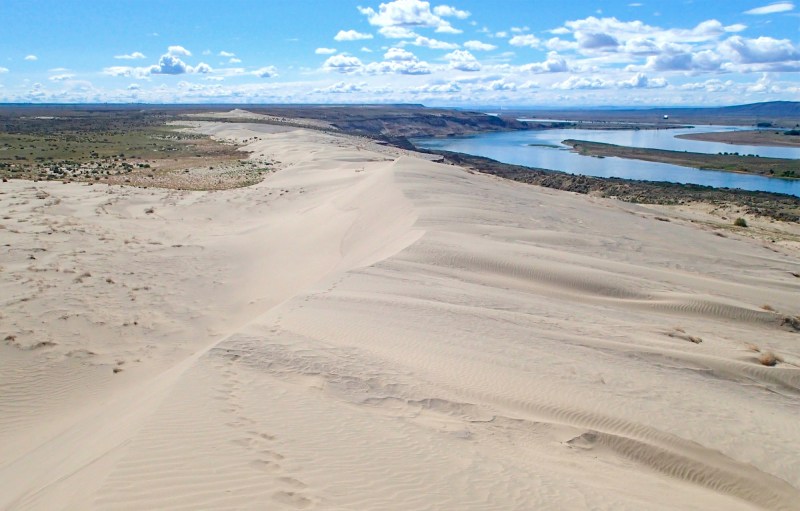
• Of geological interest are the giant sand dunes, bluff landslides and slough ponds
• Sand-adapted wildflowers, including Cusack's sunflower and sand dune penstemon
• Some of the most expansive and striking views in SE Washington on this hike
Minus Points
• Bluff edges are very unstable and dangerous, so stay clear and don't tempt fate
• Very little shade or cover on this hike, so plan to start in the early AM on hot days
• Rattlesnakes are a possibility throughout the summer, so be aware
Download (PDF, 611 KB): Photos of White Bluffs Trail
Download (PDF, 682 KB): Topo Map for White Bluffs Trail
Download (PDF, 674 KB): Road Map for White Bluffs Trail
Trail Notes
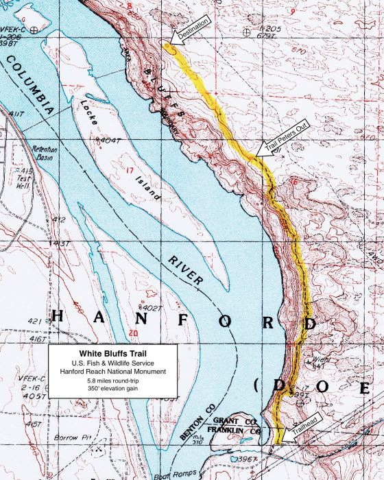
At 1.0 miles, the trail crosses the first wide expanse of sand. Look for scattered piles of ice-rafted granite rocks (bergmounds) dropped by the Ice Age floods. From here north, there are multiple trails on several levels above the bluffs. As the bluff edges are unstable and dangerous, it's wise to always seek the highest trail farthest from the edge. The views are just as good and the walking is just as easy along the higher, safer routes.
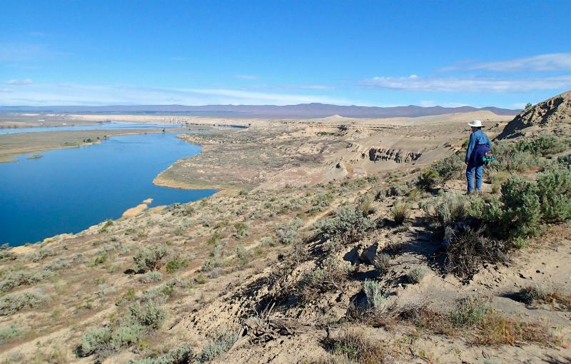
At 2.4 miles, one rounds a corner to a dramatic overlook atop some hard claystone outcrops, with views over the river and two cattail slough ponds below. This can make a good lunch spot,
NOTE: This trail remains open to the public only by the good graces of the U.S. Fish & Wildlife Service. However, it may close in the future due to safety concerns posed by the unstable bluffs. Please keep away from the bluff edges and don't be part of the problem!
Road to Trailhead
On State Hwy 24, 17 driving miles southwest of Othello, WA, and 53 miles northwest of Richland, turn south on an unmarked gravel road just east of Milepost 63. Drive through a sliding steel gate and go 3.9 miles south on a good gravel road. At a 4-way junction, just
beneath the power transmission lines, turn right (west) onto a paved road.
Follow the paved road west for 1.2 miles down the hill onto the river flats, then turn right (west) onto a dirt road leading to a small grove of locust trees. The unmarked trailhead is just east of this grove. Be aware this is a day-use site only. The entire area is closed to the public between two hours after sunset and two hours before sunrise.
Camping Options

Another full-service campground is Ginkgo-Wanapum State Park on the west bank of Wanapum Lake on the Columbia River, 3 miles south of the Vantage I-90 Bridge and about 55 driving miles northwest of the trailhead. This campground has 50 sites with full hookups, plus drinking water, flush toilets, showers and a boat ramp into Wanapum Lake. The campground is open from April through October and reservations are recommended during the summer months. Visit the WA State Parks website or call (888) 226-7688. Camping fees are based on the campsite selected.
Agency Contact: Hanford Reach National Monument, (509) 546-8300
DISCLAIMER: Every effort has been made to ensure the accuracy of this information, but the authors do not guarantee that it is either current or correct. The reader assumes full responsibility for any use of this information, and is encouraged to contact local public land agencies to inquire about current conditions before traveling.
Page last updated: 12/8/14