Less Traveled Northwest
Day Hikes for the Adventurous

Riley Creek / McClellan Mountain Trail

Hike Rating: Moderate
Hike Length: 5.5 miles roundtrip (variable)
Elevation Gain: 1,000’
Trailhead Elevation: 4,700’
Best Season: June through September
Driving Access: Any vehicle, with care
Plus Points
• The lush, cool oasis of Riley Creek contrasts with the dry uplands
• Douglas fir forest at streamside, with understory of red ossier dogwood
• Mature ponderosas on lower slopes; juniper and mountain mahogany higher up
• Sound of burbling water throughout the stream canyon
• Well-designed and well-graded trail makes for easy walking
• On upper trail, sweeping views of open hillsides and high rock ridges
• Potential bighorn sheep sightings on McClellan Mountain (take binoculars!)
Minus Points
• Best views are found 500' to 1,000’ above creek (though trail is well-graded)
Download (PDF, 583 KB): Photos of Riley Creek Trail
Download (PDF, 564 KB): Topo Map for Riley Creek Trail
Download (PDF, 648 KB): Road Map for Riley Creek Trail
Trail Notes
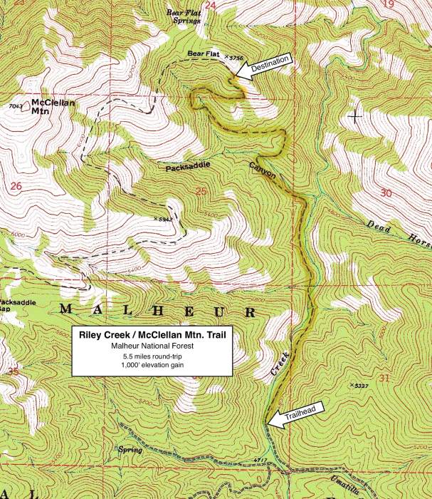
The trail then leaves the Riley Creek canyon and climbs gradually northwest into the side canyon of Packsaddle Creek. At 2.0 miles, the trail crosses Packsaddle Creek and starts a gradual ascent through open pine forests (in the wetter draws) and juniper and mountain mahogany (on the drier hillsides).

Road to Trailhead
The entire 5 miles of Road 2190 is in decent shape and accessible by any passenger car. However, there are a few rutted and rocky spots where extra care is needed.
One caution: Unless you have four-wheel drive, it’s best to park at the junction of Road 2190 and Road 589 (where Umatilla Creek meets Riley Creek), and walk the last quarter mile to the trailhead. There are some very deep mudholes in this last quarter mile, which can trap the unwary driver. Better to be safe than sorry in this case.
Camping Options
The closest developed campground is the Oregon Mine Campground, about 12 miles from the trailhead, west down the Murderers Creek canyon off paved Road 2170. This is a small campground, sandwiched between Murderers Creek and the paved road. There are four free sites, with a vault toilet but no drinking water.

Agency Contact: Malheur National Forest, Blue Mountain District, (541) 575-3000
DISCLAIMER: Every effort has been made to ensure the accuracy of this information, but the authors do not guarantee that it is either current or correct. The reader assumes full responsibility for any use of this information, and is encouraged to contact local federal land agencies to inquire about current conditions before traveling.
Page last updated: 12/21/11